
WEATHERMEN on Wednesday called on the public to continue bracing for heavy rains and the possibility of flash floods in Metro Manila and nearby areas as tropical storm Falcon (international name: Chan Hom) exits the Philippine Area of Responsibility (PAR).
Classes at all levels will remain suspended in Metro Manila, Cavite, San Mateo and Cainta towns (Rizal) and San Pedro town(Laguna), local authorities announced on Wednesday night.
The Quezon City government ordered the suspension of classes until Friday, July 10, a radio report said.
The state weather agency Pagasa said there are no storm warnings raised but the enhanced monsoon may trigger flash floods and landslides.
According to its 5 p.m. bulletin, Typhoon Falcon maintained its strength and direction as it makes its way out of the PAR.
It did not hit land as it crossed the northern portion of the country.
“Falcon is presently moving along the sea. Although there are no public storm signals, we should not let our guard down,” Pagasa forecaster Trick Moreno Hizon said in Filipino.
The typhoon was estimated at 1,065 kilometers east of Basco, Batanes, with maximum winds of 130 kph near the center and gustiness of up to 160 kph.
It is forecast to move west-northwest at 20 kph, and may enhance the southwest monsoon affecting Luzon and Western Visayas.
Pagasa is also keeping watch on another weather disturbance that may enter the PAR next week.
The storm with the international name Langka is not expected to make landfall in the Philippines but would possibly enhance the southwest monsoon (habagat).
The storm will be given the local name Goring when it enters the PAR.
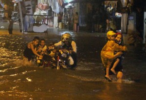
Water world
Metro Manila and nearby provinces became a virtual water world for the second straight
day on Wednesday as floodwaters submerged major streets.
Classes were suspended as early as 6 a.m. as heavy rains flooded streets with some areas in Manila and Caloocan City and Mandaluyong City already in knee-deep flood.
According to the Metropolitan Manila Development Authority (MMDA), gutter-deep flooding was experienced along Santo Domingo, Biak na Bato, Quirino, Belfast, Pedro Gil, Katarungan, Quirino Avenue to Taft Avenue and Blumentritt.
The flooding prompted the MMDA to again lift the number coding or the vehicle volume reduction scheme at 1 p.m..
The MMDA also suspended operations of the Pasig River ferry.
Continuous rains restored water level at the La Mesa Dam in Quezon City to normal after it fell to below critical level the past weeks.
The dam’s water level nearly reached the 80-meter spilling level with its water level reaching 79.58-meters at 10 a.m., Wednesday.
In a radio interview, dam manager Teddy Angeles recommended preemptive evacuation of residents near the reservoir.
The city government of Manila has set up evacuation centers at Baseco, Del Pan, Santa Ana, Blumentritt, España, Tondo and those near the San Juan River to house residents in case they need to be moved to safer grounds, Johnny Yu, chief of the Manila Disaster Risk Reduction Office (MDRRO), said.