
A man walks past a parched ricefield in Cagraray Island in Bacacay, Albay, one of the 32 provinces affected by the dry spell caused by the El Niño phenomenon. PHOTO BY RHAYDZ BARCIA
Less rainfall in PH as tropical cyclones seen altering normal course
The El Niño weather phenomenon that began this year could be among the strongest in 65 years, US government scientists said on Thursday.
The last El Niño, five years ago, had a major impact: It triggered monsoons in Southeast Asia; droughts in the Philippines, southern Australia and Ecuador; blizzards in the United States; heatwaves in Brazil; and killer floods in Mexico.
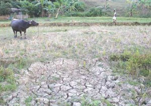
The Philippine weather bureau Pagasa early this year alerted the public to prepare for the effects of a four-month dry spell that is forecast to affect 32 provinces.
“Thirty-two provinces will likely be affected by the dry spell from August to November 2015,” the Philippine Atmospheric, Geophysical, and Astronomical Services Administration (Pagasa) said in its second semester outlook.
Pagasa identified the provinces as Isabela, Aurora, Batangas, Cavite, Rizal, Quezon, Occidental Mindoro, Oriental Mindoro, Romblon, Albay, Catanduanes, Masbate, Sorsogon, Aklan, Antique, Capiz, Guimaras, Iloilo, Negros Occidental, Bohol, Negros Oriental, Siquijor, Southern Leyte , Zamboanga del Norte, Zamboanga del Sur, Zamboanga Sibugay, Southern Cotabato, Sarangani, Sultan Kudarat, Basilan, Maguindanao and Sulu.
Pagasa expects the dry condition to intensify El Niño from “weak” to “moderate” by August and the weather phenomenon may persist until December then gradually weaken in early 2016.
“Such El Niño may likely terminate by May 2016,” it said.
El Niño comes with a warming in sea surface temperatures in the equatorial Pacific, and can cause unusually heavy rains in some parts of the world and drought elsewhere.
This year’s El Niño began in March and is forecast to last about a year.
Authorities in Australia have already predicted it would be “strong” and “substantial.”
That trend is still expected to continue, said Mike Halpert, deputy director of the National Oceanic and Atmospheric Administration’s Climate Prediction Center, on a conference call with reporters to discuss the US agency’s latest forecast, released also on Thursday.
“What is new this month is we are predicting that this El Niño could be among the strongest El Niños in the historical record dating back to 1950,” Halpert said.
The reason for the forecast is the finding that three months of average sea surface temperatures in a key part of the equatorial Pacific “could potentially reach or even exceed two degrees Celsius above normal, which is 3.6 degrees Fahrenheit above normal, a value that we have only recorded three times in the last 65 years,” he added.
Such temperatures were previously seen in the 1972-1973 season, 1982-1983 and 1997-1998.
The southern United States from Florida to central California may expect higher than normal levels of precipitation, as can the US East Coast as far north as New England, Halpert said.
The northern Rockies, Great Lakes, Hawaii and western Alaska may be dryer and warmer than normal, he added.
Even though forecasts of rain will be welcome in drought-ravaged California, Halpert said it would not be enough to refill the state’s reservoirs.
“One season of above average rain and snow is very unlikely to erase four years of drought,” he added.
Altered storm patterns in PH
Despite the prevailing El Niño, Pagasa expects an average 11 to 16 tropical cyclones to either enter or develop in the Philippine Area of Responsibility (PAR) during the June to December period.
Pagasa earlier said El Niño episodes could alter the landfall patterns of tropical cyclones.
Pagasa forecaster Fernando Cada had said lower-than-average number of landfalls could be expected in the Philippines during El Niño as tropical cyclones tend to head northward instead of crossing the country as what storms generally do under normal conditions.
He explained that lesser landfalls mean less amount of rainfall as the country would experience during a non-El Niño year.
The recent cyclone to hit the country, Hanna (international name: Soudelor), which was classified as a Category V super typhoon and dubbed as the strongest storm this year, only scraped the northeastern part of the Philippine Area of Responsibility and did not make landfall.
Soudelor, however, had severe impacts in the Northern Mariana Islands, Taiwan and eastern China, resulting in at least 37 confirmed fatalities.
Pagasa is monitoring a weather disturbance that may develop into a super typhoon which like Hanna or Soudelor is not expected to make landfall.
The state weather bureau said the storm is forecast to head straight to Japan if it continues to follow its current path.
The cyclone, which is expected to enhance the southwest monsoon (habagat), may enter the PAR by middle of next week.
WITH AFP