
With the possible entry of super Typhoon Soudelor into the country, the National Disaster Risk Reduction and Management Council (NDRRMC) will be placed on “blue alert” status starting Wednesday morning.
The alert status would take effect at 8 a.m., NDRRMC Executive Director Alexander Pama said.
“Blue alert” requires half of the agency’s personnel to be ready for contingencies.
According to the Philippine Atmospheric, Geophysical and Astronomical Services Administration (Pagasa), Soudelor is expected to enter the eastern border of the Philippine Area of Responsibility (PAR) on Wednesday and will be given the local name Hanna.
Hanna will be the 8th tropical cyclone to affect the country this year and first for this month of August and is said to be the strongest so far.
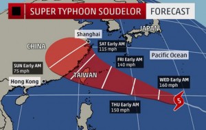
The super typhoon developed into the world’s most powerful storm of the year on Tuesday as it took aim at Japan, Taiwan and China after trashing the Northern Marianas.
The storm was roaring across the western Pacific Ocean packing wind gusts of up to 354 kilometers per hour, according to the Joint Typhoon Warning Center, which rated it a maximum category five, the same scale as super Typhoon Yolanda, which devastated many parts of the Visayas in 2013.
According to Pagasa, the eye of the typhoon was located 1,855 kilometers east of Luzon, packing maximum sustained winds of 215 kilometers per hour near the center and gusts of up to 250 kph. It is likely to move west northwest at 20 kph.
Soudelor was stronger than Cyclone Pam, the previous strongest storm of 2015, which killed at least 15 people when it slammed into Vanuatu, also in the Pacific, five months ago.
No deaths have been attributed to Soudelor but it left a trail of destruction across the Northern Marianas where acting governor Ralph Torres declared a “state of major disaster and significant emergency” after it struck late Sunday.
Pama said the super typhoon will not directly affect the Philippines and is not expected to make landfall in any part of the country but will enhance the southwest monsoon or habagat that will affect the Visayas and Mindanao.
According to the Joint Typhoon Warning Center, Soudelor is powering toward Taiwan in the north-west Pacific after causing widespread damage in the Northern Mariana Islands.
The category 5 storm is expected to strengthen further, with sustained wind speeds of 150 knots, or 277.8 kph later on Tuesday, US space agency NASA said.
The center is predicting that wind speeds could reach 160 knots, with gusts reaching 195 knots, or 361 kph.
A typhoon gains “super” status once sustained winds reach 130 knots.
NASA said the typhoon was dumping rain at the rate of 58 millimeters an hour, according to satellite readings.
The storm is expected to track toward northern Taiwan and hit mainland China in about four days’ time, although it will have weakened by then, NASA said.